
Latest version of this document | Fadaiat project web site | Project collaborators | More photos here
la_multitud_conectada | More articles here
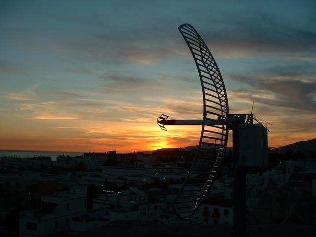
Parabolic antenna in the evening Sun, Summer Solstice 2004, Tarifa, Spain.
This article in a previous incarnation was posted to Slashdot during the Transacciones / Fadaiat event in June 2004. This was not done by any of the project collaborators and the post did cause some misunderstanding amongst some them as it was acredited to Psand.net, when in reality a large number of groups and individuals were involved. You may however still wish to read the Slashdot posting and comments.
This article details the technical procedures, experience, issues and results surrounding the accomplishment of a wireless computer network IP link across the Strait of Gibraltar using 802.11b technology as part of the Transacciones / Fadait project that took place on the 22 and 23 June 2004. The aim of this article is not only to provide a technical reference for those interested in setting up a similar link, but also to put the achievement into its correct social, cultural and geopolitical context that is consistent with connecting the continents of Europe and Africa.
Note: the wireless link traversed some 32 kilometres (19.9 miles) of water. This is by no means the longest recorded distance for an 802.11 wireless network. At the time of the project, the greatest distance was 70.5 kilometres (43.8 miles) between the Canary Islands of Gran Canaria and Tenerife. Recently, during the WiFi Shootout competition which took place during DefCon 12 in Las Vegas, a wireless link of 88.7 kilometres (55.1 miles) was achieved without amplification. The main point to bear in mind when reading this article is the fact that, to our knowledge, it was the first 802.11b wireless link between Africa and Europe and that we were working in a complex geopolitical and cultural environment.
First a very brief history of the area. Tarifa is located in what is today the Spanish province of Andalusia. This name comes directly from the Moorish name of Al-Andalus, given to the region controlled by the Moors for over seven hundred years during the middle ages (711 - 1492 CE); although it should be noted that for only a small amount of time in its history did the borders of Al-Andalus correspond to those of modern-day Andalusia. With the fall of Granada in 1492, the region was 'reconquered' from the Moors by Ferdinand II of Aragon and Isabella I of Castille (los Reyes Catóolicos / the Catholic Monarchs). In the same year Christopher Collumbus discovered America (supposedly) and the Jews were expelled from Spain.
Gibraltar comes from Arabic and is named after the general Tariq ibn Ziyad and means Tariq's Mount (Yabal Tariq) in Arabic. Gibraltar was taken by the British in 1704 and since the 1713 Treaty of Utrecht between Spain and Great Britain, it has been a sovereign dependency of the United Kingdom.
The Gibraltar Strait is stage to a constant stream of human traffic, people risking their lives for a perceived better life in Europe than they could have in Africa. Almost every day (and often several times a day) small boats and rafts arrive crammed with Africans from all countries and races trying to enter Europe to find work and better prospects. Many die in the attempt. The currents and winds around the Strait, where the Atlantic Ocean meets the Mediterranean Sea are infamous and many people fall foul of exposure, starvation or drowning in the attempt to cross it.
The coasts are constantly monitored - the Strait is one of the most (if not the most) watched stretches of water in the World - and those who do make the treacherous crossing are often, upon their arrival in Spain, greated by a welcoming party of the Spanish Civil Guard (Guardia Civil) and after receiving medical treatment (in many cases for dehydration and hypothermia) from groups such as the Red Cross, are ferried off to a detention centre where they are kept for some time before being deported back to where they came from. Sometimes the people succeed in avoiding the authorities and sometimes they are rescued by local people, for altruistic or otherwise less well intended purposes. In all cases, even if they make it to Europe, they are thereafter illegal and under constant threat of arrest and deportation and are subsequently open to abuse from unscrupulous employers.
Whatever your political stance regarding immigration and the freedom of movement, I think the degree of human tradgedy is such that no person could put their hand on their heart and say they do no feel at least some inkling of remorse for this situation. The great disparity of wealth and opportunities between Europe and Africa, the perhaps repressive regimes that rule their countries of origin, forces these people to seek what any human being should have a right to: a dignified and tolerable existence. That they risk their lives for this (although many I suspect are unaware of the risks when they pay their money to the raqueteers who run the boats) is deserving of our respect and understanding; it does not merit encarceration, nor treatment as a third-class citizen, or barely a citizen at all.
Transacciones / Fadaiat was an ambitious proposal for a two-day event taking place simultaneously in Tarifa (Andalusia, Spain) and Tangiers (Morocco). The project formed part of the Arte y Pensamiento (Art and Thought) project, devised by the Universidad Internacional de Andalucía (International University of Andalusia) to promote social and cultural activities through debates and the production, diffusion and consolidation of comtemporary thought and creativity. Transacciones / Fadaiat dealt specifically with freedom of movement and knowledge in the contexts of immigration, the Internet and free software.

Conceptual geography of network for Transacciones / Fadaiat
Although strictly speaking not necessary for the construction of the wireless link across the straight, we detail here the entire infrastructure of the network deployed for the event as a point of reference; the link would have been useless without a network behind it.
Much of the event's activity took place in the castle of Guzman el Bueno in Tarifa, which was effectively occupied (or overrun) for several days. The castle is situated on the coast of the Gibraltar Strait and overlooks the historic town and the point where the Mediterranean Sea becomes the Atlantic Ocean - the southermost point of the European continent. The project used nearly all of the available space. Presentations and round-table discussions around the theme of freedom of movement and freedom of knowledge were to take place in the old Church (which was once a Mosque) during the day and there were to be performances and a media-lab in the two large patios that form the centre courts of the castle during the evening and into the night. On the second day, we were to move the media-lab down to the beach for the festivities of San Juan (the Catholic version of the Pagan Solstice festival; the Solstice itself having actually taken place on the 22nd June, two days before).
Connection to the Internet was provided jointly by an 2Mb/s ADSL connexion from the town library adjoining the castle and the use of a bi-directional satellite dish provided by Psand (comprising a Norsat dish and an EMS Technologies satellite terminal) connected to the Internet via the Astra satellite network. For more details of this unit and its operation, please refer to this previous article. The dish gave us a connection of up to 2Mb/s down the way and 384Kb/s up the way; although tests we have made show this to be commonly (or more reliably) in the region of 1.5Mb/s down and 250Kb/s up. The ADSL provided us with up to 2Mb/s down the way and a supposed 320Kb/s up; although it must be noted that such speeds are never reached continuously.
Two connexions were employed as we needed their combined up-stream bandwidth to facilitate streaming the event live to the Internet.
As we were dealing locally in Tarifa with five separate spaces (church, castle entrance, large patio, small patio and beach), we decided to provide network access to each of these spaces via a combination of wired and wireless connexions. For their part, the local council had run good quality Ethernet cable from the library near the castle forecourt to the church, the two patios and the castle rooftop (adabe). To the ends of each of these cables we connected standard wireless base-stations. The models we used were Buffalo Technologies WBR-G54, which although capable of 54Mb/s, complying to the 802.11g standard, were actually configured to use the older 802.11b 11Mb/s standard as we needed to ensure that the majority of wireless clients could connect to our network. This model also comes with a 4 port switching hub, which is useful for connecting machines to, or for connecting to another switch to connect many machines to. We connected each of the cables to one of the LAN ports on the base stations.
At the library end we installed yet another of the same type of base station and connected one of the LAN ports to the switch that connected all the other network cables. The base station was connected to the library's ADSL router via its WAN port and was configured to run a DHCP server to provide IP addresses to client computers on the castle network. The library base station was therefore set up as a router and acted as a kind of basic firewall between the library's network (and outside world) and the internal network.
Each wireless base-station was given a name so that it was easily distinguishable, although this was largely unnecessary as we did not experience interference due to the distances involved and the thickness of the castle walls.
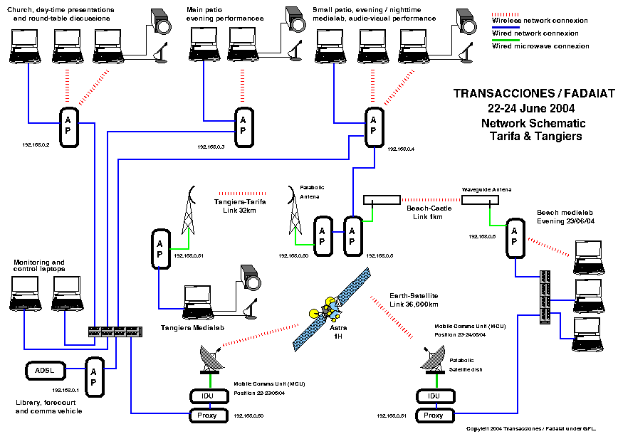
Schematic of network infrastructure for Transacciones / Fadaiat
(Note two different locations of satellite communications vehicle: castle and beach)
Download XFig version of network schematic.
| IP Address | Funcion |
|---|---|
| 192.168.0.1 | Default Internet gateway for network (via ADSL) Wireless access point (forecourt) |
| 192.168.0.2 | Wireless access point (church) |
| 192.168.0.3 | Wireless access point (large patio) |
| 192.168.0.4 | Wireless access point (small patio) |
| 192.168.0.10 | Wireless access point (Beach link: castle) |
| 192.168.0.11 | Wireless access point (Beach link: beach) |
| 192.168.0.50 | Wireless access point (Striat link: Tarifa) |
| 192.168.0.51 | Wireless access point (Strait link: Tangiers) |
| 192.168.0.60 | Internet gateway (via Satellite) |
| 192.168.0.170 - 219 | DHCP leased IP addresses |
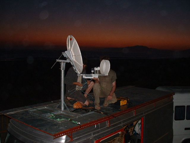
For the rooftop connection, a pigtail was connected to the base-station's external antenna port and then, using N-type connectors, to a URM67 (microwave coaxial) cable running up a tripod mast to a home-made wave guide cantenna. The wave guide antenna was orientated to point at the beach, where the medialab would take place on the evening of the 23 June 2004.

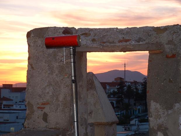
Wave guide 'cantenna' pointing towards the beach in Tarifa. Also can be seen the marina, which was a strong source of noise.
Given that this event took place simultaneously in several locations, we detail here a little about each place in order that the entire picture of what went on be a little clearer.
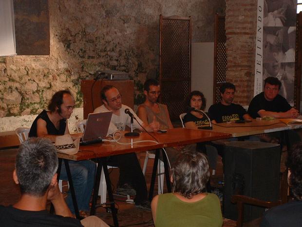
In the church during both days there took place sessions of presentations and discussions by representatives of the many groups involved in the project. Accompanying the presentations were videos and photographs projected onto a large screen. The group Zemos98 produced and recorded the entire event as a live television programme under the name of Transacciones-TV and the feed was streamed continuously throughout the day in QuickTime format to Darwin Streaming Server and MPEG4 format to Ffserver. Following the presentations, a series of round-table discussions took place to draw conclusions and make proposals for future movements and collaborations.
The Transacciones.TV web site is available here.
Presentation of Fadaiat Lab in the church
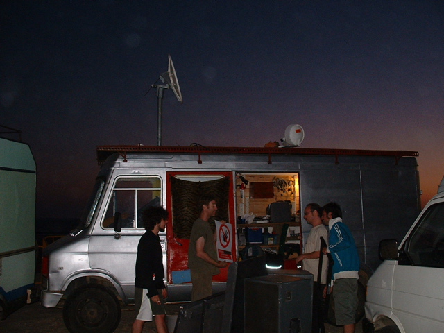
In the forecourt of the castle we located a satellite communications and editing vehicle that acted as the network operations centre for the event. The van was parked next to the library, where the existing ADSL connexion was situated and a feed from this was taken into the van. This connexion, and that of the satellite were multiplexed to provide sufficient bandwidth for necessary streams.

Mobile Communications Vehicle in castle forecourt with dish mounted
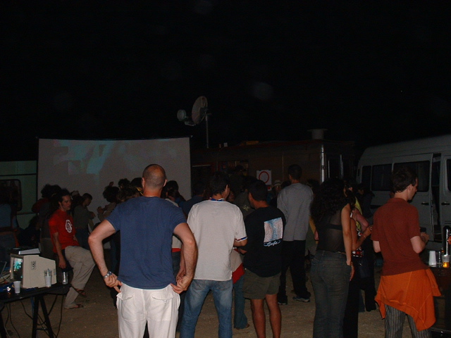
During the evening and into the night, various performances took place by Zemos98 and Miguel Benlloch. Audio and video mixing desks, spotlights and a very large screen accompanied the artists. Salud Lopez performed there on the second night with an amazing spectacle.
The small patio was home to the Fadaiat Lab, a space for people to collaborate via the exchange of knowledge and experience in the domain of free software.
There were a total of four video projectors and four screens that were fed by a matrix video mixer taking it's input from numerous people who were producing video output from short films, images and the Internet using Pure Data and PiDiP. Audio was also centralised into a mixing desk, taking feeds from several computers and decks. For streaming the feeds from the sound and video desks were also fed to two separate machines dealing with feeding the QuickTime, Ffmpeg and Icecast streams to the world at large.

Fadaiat Lab set-up during daytime
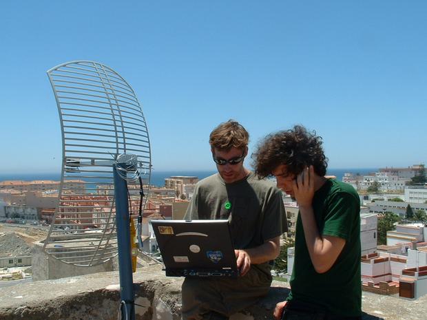
Setting up the medialab and satellite connexion and the lab in full-swing, on the beach at Tarifa
The well-known Café Hafa was the original destination for the Tangiers media lab. Unfortunately there were logistical problems with this location and the lab was moved to a nearby location. This new location was where the Tangiers side of the wireless link was established. A small-scale media lab operated from there with invitees from local organisations.
During the second day we did a live video link-up with the Ecole National des Sciences Appliqueés (National School of Applied Sciences) to the church in the castle. Due to restrictions on travelling to Europe for Moroccans, people from the Moroccan organisations went to the ENSA and over a live video link presented and discussed issues with their colleagues and counter-parts who were in Tarifa.
The ENSA had a Polycom ViewStation SP, an integrated video conferencing device with web camera that can send streamed images at up to 768Kb/s over Ethernet and 128Kb/s over ISDN. At the Tarifa end we used a computer running GnomeMeeting under X and GNU/Linux to send and receive images.
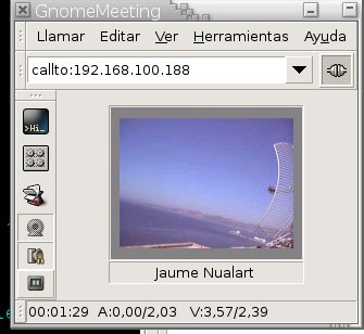
GnomeMeeting session across the Gibraltar Strait, looking north-east
It was a requirement to provide streams to the internet for the duration of the event. We decided to send three independent streams, one video using FFmpeg, one video using QuickTime and one audio using Icecast. We decided to use two video streams in order to offer the maximum available platform and player support. The audio stream was decided upon to provide for low-bandwidth users and listeners and those wished to retransmit the stream over terrestial radio or during their own events.
Actually getting to the point of being able to install and test the wireless link was quite a challenge, not only assessing and specifying the correct equipment to use, but also because of the need to obtain permission and a location for the link on the Morroccan side of the Strait. This section details the steps taken to get to the point of doing the link on the day and what the results were.
Here are the notes drawn up by Dave previous to the event.
Based on our previous experience and the experience of other people, we were able to rougly determine the equipment we would require. Although others had done links of similar, and in some cases much farther distances, we were uncertain as to whether the fact that the link was over water and the high degree of marine traffic and radio interference in the Gibraltar Strait would adversely affect the results. Here we list some of the previous wireless links and projects that we drew upon for inspiration and help.
Note: we will add more links here once we have them.
We were required to get the appropriate permission from the Tangierian and Moroccan authorities for the wireless equipment. This was a fairly lengthy process as we ascended through the echelons of Moroccan government. On the Tangiers side the support of Mar Villaespesa (UNIA), Helena Maleno and Meme Jimenez (Colectivo Aljaima), Wiam Mohad (Fadaat) who had interviews with the mayor of Tangiers, the Wilaya (provincial governor) and the Moroccan authorities, were indespensible in making sure that we did things in the correct manner. Mike Harris and Iván Pizarro worked to complete a technical document which we needed to submit to the Moroccan authorities for permission. This was slightly difficult as we had to work in French as well and Iván did a sterling job in obtaining the information required and completing the form. We were given permission by the Moroccan authorities on the Monday, just one day before the event was due to take place.
Download the PDF of the technical data provided to the Moroccan government (56KB).
Iván and Pablo performed a dummy run test of the link between Santa Pola and Torrvieja about three weeks before we did the real thing. They used the same equipment as for the real link. We are waiting for details, results and photos of this dummy run to be able to insert here.
The distance from Tarifa to Tangiers is approximately 32,000 metres (19.9 miles), the large majority of this distance over water. The stretch of water is extremely laiden with nautical traffic and there is a large amount of electromagnetic interference. Whilst planning this out, we had our concerns as to what degree the amount of naval traffic and electromagnetic interference in the Strait would adversely affect the connexion.
For the wireless link across the Strait we used a Senao NL-2611AP3 access point (note link doesn't seem to work well on Mac), a one watt amplifier at 12dB and a 24dB parabolic antenna (110 x 60 cm) at either end. This equipment was provided by Globaltelesat. According to Senao's web page, the NL-2611AP3 access point has a theoretical power output of 100mW but after a firmware upgrade done by Iván, this was increased to 200mW. The amplifiers were bought and installed to enable us to boost the link power by up to one watt and with the 24dB antenae, we were preported to have an amplification of around 45dB.
The first problem we experienced was with the amplifiers. It seemed that they weren't actually helping us to achieve a connexion. This could be because in amplifying the signal, they were actually generating more interference, although this is unproven. In the end, we simply removed the amplifiers and things started to work better.
Then we experienced problems with one of the two Senao base stations. The one in Tarifa seemed to loose it's configuration completely and given that those in the Tarifa team were unfamiliar with the Senao base stations, it was decided to swap it out and instead install a Buffalo Technologies WBR-G54, which they were more familiar with. We configured the two base stations to use the same wireless channel and to have sequential local network IP addresses. Using mobile phones (the advantage here was that near the coast in Tangiers, a Spanish mobile will just connect to a network in Spain) we orientated the two antennae in approximately the right direction (it was a clear day and we could actually see over to the other side fairly clearly)
The next challenge was that that Tarifa marina has an 802.11b network and this was immediately between the Castle and the Sea. The signal from this was extremely strong, being so close to the parabolic, thus we needed to change channel to be as far away from them as possible to avoid interference to us and them. Unfortunately the other problem from this was that with the Marina signal being so strong, the monitoring application being used (Wavemon on GNU/Linux) to aim the Castle end of the link kept jumping from the very weak signal in Morocco to the very strong signal in the Marina. Even when using the commandiwconfig eth1 essid tanger
for some reason Wavemon continued to jump back to monitoring the Marina. We did not find a work around for this apart from much patience and catching glimpses of Tanger basestation and using these glimpses to aim until the Tanger signal was strong enough for Wavemon to lock on to.
During this phase of the aiming a very large container ship pulled in front of the Moroccan end of the link and we lost them for at least five minutes.
Once a strong enough signal was received it took some easy fine adjustments to the parabolic aim, locked it in position and we acheived good connectivity. We ran the ping command and got a good ping time and a constant connexion with very low packet loss.

The Straits-link team in Tanger. |
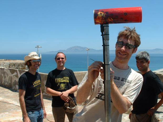 
The Straits-link team in Tarifa |
Once we had the link working, having removed the amplifiers and swapped out the base station at the Tarifa end, we had a good and constant connexion for several hours. We were able to achieve and maintain a signal strength of around 15dBi and a network speed of around 1Mb/s. This was sufficient to be able to stream some video via a web camera from Tangiers to Tarifa and vice versa.
After about six hours, the link unfortunately suddenly stopped working. Upon investigation we discovered that someone had put the antenna in Tarifa out of position. We then attempted for quite some time to get the link back working again, which was not possible because we could not get even glimpses of the Moroccan signal. We remain uncertain as to what caused this. There was a bank of fog lying across the Moroccan coast so absorbtion could have played a part although it is doubtful if it would cause a loss of 12 dB at 2.4GHz. It could be that the atmospheric refraction had inverted so that the hump of the earth (the curvature of the Sea) was now obstructing the beam as we did not have quite the required antenna heights (see link calculations). It could have been because some large naval object had unfortunately postioned itself in our beam. Perhaps we were even being blocked out by the Powers That Be?
The wireless link and the project Transacciones / Fadaiat was achieved through the collaboration and efforts of many people.
There were rather too many people involved in this project to list them here within this article. Here is full list of collaborators of the project.
Please note this article is quite old and some links may well no longer work.
The word fadaiat is from Arabic and means 'spatial objects' - satellites and everything associated with them. It is roughly pronnounced like fadai-yat. It appears to come from the Arabic word fada'at (pronnounced fadah-at, which means 'space', 'sidereal', 'astral'. Many people, for example, use the word fadaiat to decribe even parabolic satellite dishs themselves, much in the same way that in English people often (and mistakenly) called them satellites.
The reason that the ping time when using a satellite for Internet access is so long is a factor of the physical distances involved. A geostationary satellite is roughly 36,000km away, and the radio signals, travelling at around the speed of light (300,000km per second) have to reach the satellite and then route back to the network operations centre providing the Internet connexion. If the send and return path are via the satellite (bi-directional) then the radio signal path is four times the distance to the satellite, or around 144,000km. A quick bit of arithmetic; 144,000 divided by the speed of light 300,000 gives roughly 500ms or half a second. Add a small amount of delay for network processing at each stage and you end up with around 650ms delay. This latency is not noticeable in non-interactive medium such as satellite television.
LFNs require a change in a number of network parameters including the TCP (Transmission Control Protocol) send and receive window sizes (refer to RFC 1072 for more information) and this change need be made solely on the proxying machine, as it will be the one that makes the actual request over the LFN and not local machines running on the LAN; thus removing the need to make adjustment to network settings on every machine needing to use the connexion. The other obvious advantage is that it can act as a firewall to the outside world and hence protect the connected network to a large degree.
To make the change to the TCP send and receive window sizes under Debian GNU/Linux execute the following commands:
echo "4096 120000 120000" > /proc/sys/net/ipv4/tcp_rmem
echo "4096 200000 200000" > /proc/sys/net/ipv4/tcp_wmem
You can make these settings permanent by ensuring that they are set in the file /etc/network/interfaces:
up echo "4096 120000 120000" > /proc/sys/net/ipv4/tcp_rmem
up echo "4096 200000 200000" > /proc/sys/net/ipv4/tcp_wmem
The above should work for other distributions, especially Debian based ones.
Note these technical notes from hereonin were taken from the original page of notes. They were written quite a while before the project took place and were posted to Slashdot in June 2004. These notes were not intended to be made public at the time and were published without our knowledge. We were preparing this, the a proper article to explain the context of the work done and to give full details of experiences whilst doing it.
It must be noted that the calculations from hereon in have been derived from an amalgamation of equations found on the Internet. There appear to be discrepancies between the various sources found, so should be used as guidance only. A visit to the library is planned in order to iron out the discrepancies.
The distance from Tarifa to Tangiers: 32,000 metres, mostly over water. There is a shorter link available to Ksar-es-Seghir, Morocco which is 20,000 metres.
Tarifa antenna position: On top of the castle (Castillo de Guzmán el Bueno) 20 - 40 metres above sea level.
Tangiers antenna position: Presently unknown.
At a range of 32,000 metres.
|
|
10 dB is on the low side of acceptable, 16 to 20 dB would be preferable. This link budget assumes that the antennae are connected to the amplifier with the minimum of cabling. If more cabling is used, the losses in this must be accounted for.
The free space loss at 32,000 metres was calculated using javascript online calculator
| Make | 11Mbps | 5.5Mbps | 2Mbps | 1Mbps |
| Orinocco cards PCMCIA Silver/Gold | -82 | -87 | -91 | -94 |
| CISCO cards Aironet 350 | -85 | -89 | -91 | -94 |
With water being the main surface for the connexion, the maximum point of the first Fresnel zone will be equidistant from each antenna i.e. the obstacle (water) is in the middle of the signal (d1 = d2).
R1 approximates to SqrRoot(lambda x d1 x d2/(d1+d2))
valid for d1,d2>>R1 where:
Note: Only 60% of the first Fresnel zone (0.6 x R1) is needed for a line of sight connection.
Therefore at a range of 32,000 metres:
lambda = 0.122 m
d1 = 16,000 m
d2 = 16,000 m
R1 = SqrRoot(967)
R1 = 31.1 m
R1 x 60% = 18.7 metres
Thus, to allow for 60% of the first Fresnel Zone, the mid point of the connection will need to be 19 metres above the sea to maintain a radio connection. Therefore both antennas will need to be at least 19 metres above the top of the bulge in the sea (see below for the height of the bulge). This assumes that there are no other obstacles on land to deal with.
It seems this is not the only way to calculate the Fresnel zones, but each technique yields roughly the same answer.
h = r(1-cos((PI x d) / (2 x PI x r)))
Angles in radians
It should be noted that due to refraction the Earth curvature is reduced therefore the radius is considered to be 4/3r. This yields a result of 24 metres.
This calculation assumes the planet is a sphere, which is not quite true (very untrue in some places - but the sea is a pretty good approximation) and it appears from research that there is some discrepancy in calculating the earths curvature. It does not appear to create a great difference in the answers.
With 60% of the first Fresnel zone being 18.7 metres and the Earth bulge at the centre of the link being 24 metres, it would seem that to get a clear radio line of sight at 32 kilometres around 43 metres of clearance above the sea will be needed.
This is definately not a "brickwall" limit, a link may still be possible without this clearance, although more power / receiver sensitivity may be needed.
I have checked this result against various online information and give or take 5 metres this appears to be a good approximation.
Reflexions can be a problem over water. There are various ways to remedy this.
Atmospheric absorption (haze, mist, fog, rain or snow) is minimal at up to 5 GHz, but will still constitute a loss. Details to follow.
We identified possible sourcces of noise pollution, such as radio signals from ships and listening posts, humidity and physical objects, such as ships in the Strait. Some methods of avoiding noise include:
Initial aiming may be helped by telescope, compass, GPS, possibly using strong spotlights at night.
Communication during aiming, before a connection is established, may be difficult. Mobile phone? Code (Morse?) using light may be slow but reliable. Assuming times to communicate are set up.
This could be a problem. The 'levante' (east wind) can blow up unexpectedly and can be extremely strong (enough to make most people stay in doors). The physical strength of the antenna and mount must be capable of maintaining aim at well above the speed of this wind. A perforated dish for lower wind resistance may be a good idea.
Authors: Mike Harris, Dave Gough
Version: 1.12 (updated 2015-03-08)
Written using GNU Emacs and Bluefish. Photos manipulated with The GIMP, figures drawn with XFig.
Article copyright (c) 2004 Transacciones / Fadaiat and the individual authors. Permission is granted to copy, distribute and/or modify this document under the terms of the GNU Free Documentation License, Version 1.1 or any later version published by the Free Software Foundation; with no Invariant Sections, with no Front-Cover Texts, and with no Back-Cover Texts. A copy of the license is included in the section entitled "GNU Free Documentation License".

![]()